Canada Gazette, Part I, Volume 156, Number 26: Supplement 2
June 25, 2022
FEDERAL ELECTORAL BOUNDARIES COMMISSION FOR THE PROVINCE OF MANITOBA
Proposal of the Federal Electoral Boundaries Commission for the Province of Manitoba
Preamble
Introduction
Every 10 years, after the decennial census is completed, the important democratic process of electoral boundary redistribution takes place. Redistribution is meant to reflect population growth and population movement among and within provinces. There are two steps in the redistribution process.
The first step involves a recalculation of the number of seats in the House of Commons given to each province, based on new population estimates and a complex formula contained in the Constitution. After the current redistribution, the number of seats in the House of Commons will increase from 338 to 342. Manitoba will retain the same number of seats that it had before the current redistribution process; that is, 14 seats.
The second step involves the establishment of 10 independent electoral boundaries commissions, one for each province. Each commission has three members: a chair appointed by the chief justice of the province and two other members appointed by the Speaker of the House of Commons.
As in other provinces, the task of the Federal Electoral Boundaries Commission for the Province of Manitoba is to readjust the boundaries of the province’s 14 electoral districts (also called “constituencies” or “ridings”) to reflect growth and shifts in population, and to assign names to the ridings.
The main purpose of our Commission is to adjust boundaries so that each riding contains roughly the same number of people (we work with total population, not the number of voters). However, as described in more detail below, the Commission is also obligated to consider several other factors when determining the boundaries and names of ridings.
Pursuant to the Electoral Boundaries Readjustment Act (the Act), the Commission is required to prepare and publish preliminary maps of proposed ridings and to hold public hearings at which individuals and groups can express their views on those proposals. These public hearings will be held either in person or via videoconference. Suggestions and feedback on the preliminary maps can also be submitted by letter, e-mail and telephone, or by using the interactive map viewer at redecoupage- redistribution-2022.ca.
Once we have heard the various viewpoints, the Commission will review its proposal and draw a final electoral boundaries map.
Before becoming official, however, the proposed final map is tabled in Parliament, and members of Parliament (MPs) have the opportunity to express before a committee of the House of Commons their agreement or disagreement with the proposed new boundaries and any proposed name changes to Manitoba’s 14 ridings.
Given that MPs have intimate knowledge of the communities they serve and are actively involved in the process of representing them, their views on the proposed maps must be given serious consideration by the Commission. However, to ensure an objective application of the representation principles stated in the Act, the Commission will make the final decision on the boundaries and names of ridings.
Since the Commission has significant discretion in drawing boundaries and makes the final decision on the maps, it is important that we promote maximum public participation in this key democratic process. That process is intended to establish relative parity of the vote, while ensuring that MPs are accessible to their constituents and can be responsive and effective spokespersons on their behalf. Later in this document, we describe the ways by which interested citizens can express their views during the redistribution process.
The Starting Point
In February 2022, Statistics Canada released the new population counts from the 2021 Census for each of Manitoba’s 14 electoral districts. Manitoba saw an 11% overall increase in population since 2011. All electoral districts but one experienced population growth over the past decade. There was, however, significant variation in the rate of growth among them. For example, Winnipeg South saw an increase of 27,830 in its population, while Charleswood—St. James—Assiniboia—Headingley saw an increase of 2,903. Similarly, the population in Provencher increased by 20,850, whereas Dauphin—Swan River—Neepawa added 2,129 people. Churchill—Keewatinook Aski was the only constituency to actually lose population. It experienced a drop of 3,890 people (4.57%) between 2011 and 2021. These population changes necessitate adjustment to the boundaries of Manitoba’s electoral districts, to achieve greater voter parity.
Table 1 shows the total population of Manitoba to be 1,342,153. When divided by 14, this produces a population average of 95,868 per riding. The table also displays the variance or deviation from the provincial average for each riding.
| Riding Name | 2021 Population | Variance from Average | Variance in Percentage |
|---|---|---|---|
| Brandon—Souris | 89,812 | -6,056 | -6.32% |
| Charleswood—St. James—Assiniboia—Headingley | 84,767 | -11,101 | -11.58% |
| Churchill—Keewatinook Aski | 81,258 | -14,610 | -15.24% |
| Dauphin—Swan River—Neepawa | 89,503 | -6,365 | -6.64% |
| Elmwood—Transcona | 101,691 | 5,823 | 6.07% |
| Kildonan—St. Paul | 91,480 | -4,388 | -4.58% |
| Portage—Lisgar | 100,417 | 4,549 | 4.75% |
| Provencher | 109,445 | 13,577 | 14.16% |
| St. Boniface—St. Vital | 95,514 | -354 | -0.37% |
| Selkirk—Interlake—Eastman | 101,373 | 5,505 | 5.74% |
| Winnipeg Centre | 87,499 | -8,369 | -8.73% |
| Winnipeg North | 101,221 | 5,353 | 5.58% |
| Winnipeg South | 113,370 | 17,502 | 18.26% |
| Winnipeg South Centre | 94,803 | -1,065 | -1.11% |
| Total population | 1,342,153 | ||
| Provincial riding average | 95,868 |
To reflect population growth and shifts, this Commission has the mandate to adjust boundaries on the basis of criteria established by the Act. Subsection 15(1) of the Act requires that the population of each riding be as close as is reasonably possible to the provincial average, or “electoral quota”, which for Manitoba is 95,868.
The Act, however, also requires the Commission to consider several other factors. A riding’s population may vary from the provincial average by up to plus or minus 25% if the Commission considers that variance necessary or desirable in order to:
- respect communities of interest or identity (for example, communities based around language or shared culture and history);
- respect historical patterns and the continuity of previous riding boundaries; and
- maintain a manageable geographic size for ridings in sparsely populated, rural or northern regions of the province.
We did not see a need to exercise this wide latitude when drawing the boundaries for any of Manitoba’s 14 ridings, but we have sought to balance a primary commitment to reasonable parity of the vote in all parts of the province, with recognition of the other considerations that are relevant to effective representation.
Public Participation
The Commission considers the process of boundary readjustment to be a key democratic moment in establishing fair and effective representation for Manitobans in the House of Commons. To this end, we wish to encourage and support the maximum feasible amount of public participation in the process.
As was done by the 2012 Commission, the current Commission reached out at an early stage in its work to a wide range of organizations and individuals, announcing the commencement of our work and inviting them to provide comments on the principles and criteria that would guide the development of our proposed maps. There was also publicity in conventional and social media across Manitoba.
The Commission also prepared a Guide to Participation in the electoral boundary readjustment process, which can be found on our website at redecoupage-redistribution- 2022.ca. We received a variety of submissions, including several offering detailed descriptions of potential changes to the boundaries. We incorporated some of these suggestions into this proposal. We thank those individuals and organizations for their input in this first phase.
To support transparency and fairness, the Commission decided to post written submissions on the website. This will enable interested organizations and individuals to review the proposals and supporting evidence being presented by others and to learn from the representations being made.
We will continue to welcome input throughout the course of our work, whether by regular mail, e-mail or telephone. Interested individuals, groups and organizations can consult our website at redecoupage-redistribution-2022.ca for more information on the boundary readjustment process. Contact information for all modes of communication with the Commission is found there and at the end of this proposal.
In describing our preliminary maps in this document, we have sought to identify clearly and fully the challenges that we faced in terms of balancing voter parity and effective representation. We identify the parameters in terms of population variation among the constituencies that we consider desirable. We explain how we assigned meaning to and applied elusive concepts such as community of interest and manageable geographic size that can be effectively serviced by an MP. In this way, we hope to make it easier for people to respond to our initial thinking on how to achieve effective representation.
In explaining the changes proposed for the boundaries of Manitoba’s 14 ridings, we have decided to highlight only what we judged to be the most significant transfers of territory and population centres from one riding to another.
We recognize that people will be interested to learn whether changes are proposed for their communities. We encourage them to study the maps in detail and to share their opinions and feedback with us. The province is vast and comprises many diverse communities. As the Commission cannot be aware of all local social and economic circumstances, we welcome advice from Manitobans.
In developing our schedule of public hearings (see below), we have planned to visit parts of the province where major changes to the boundaries of constituencies are being proposed. In person hearings have been scheduled for Winnipeg, Brandon and Steinbach. A virtual hearing has been scheduled for Thompson. The final hearing will be a virtual hearing intended for the entire province of Manitoba. Simultaneous translation will be provided at the hearing in Winnipeg and in the virtual hearing for all of Manitoba. We have also scheduled our hearings at 7:00 p.m. to facilitate participation.
We wish to emphasize that members of the public may attend and participate in any hearing they wish regarding the Commission’s proposals. Participation in the hearings and representations from the public are not limited to the area where a hearing is held. For example, persons who would like to make a submission about a proposal that doesn’t involve any of the electoral districts in Winnipeg may still attend the meeting in Winnipeg to make their submission.
In addition to registering to make a presentation before the Commission at a public hearing, individuals are also welcome to attend the hearings. However, due to technological constraints, even if you do not wish to make a presentation, you must register beforehand if you wish to attend a virtual hearing. Following the formal presentations at each hearing, the Commission will determine, at its discretion, whether to receive further comments from the floor.
Guiding Principles
As did our predecessors in 1992, 2002 and 2012, our Commission accepted as a fundamental principle the desirability of population equality among all ridings (such that each vote cast in the province shall have approximately the same weight) and set a tolerance goal of plus or minus 5% from the provincial average. During past redistribution processes, no one has challenged, in general terms, the reasonableness or fairness of this guiding principle, although there have been objections to how it has been applied to the boundaries proposed for particular ridings. We saw no basis to deviate from this deep-rooted principle, and therefore adopted a ±5% guideline.
Other considerations include geography, community interests and history, and minority representation. A more in-depth description of our guiding principles can be found on our website at redecoupage-redistribution- 2022.ca.
Manitoba’s 14 ridings can be divided into two groups: the eight Winnipeg-area ridings and the six mostly rural ridings. The Commission faced a similar challenge for each group: proposing boundaries that would ensure, to the extent reasonably possible, that the population of each riding would remain within 5% of the provincial average over the course of the next 10 years. To accomplish this, we decided to factor in population projections.
At the time of writing, the City of Winnipeg had not released a population growth analysis that factored in the 2021 Census, although the Commission did have the benefit of one prepared in 2016. Nonetheless, as a result of the 2021 Census, the Commission was able to determine neighbourhoods where significant population growth occurred. We also researched growth projections for various neighbourhoods and factored those into our considerations.
For the six constituencies outside of the Winnipeg area, we assumed that existing population trends would largely continue over the next decade, with some variations (for example, anticipated incremental growth in the City of Brandon).
In the City of Winnipeg, the electoral district of Charleswood—St. James—Assiniboia—Headingley posed a particular challenge. As earlier stated, the population of that constituency grew by only 2,903 between the 2011 and 2021 censuses. The result was that, in 2021, the population in that riding was 11.58% below the provincial average. To address this disparity, the rural municipalities of St. François Xavier and Cartier, as well as a small amount of territory from the eastern area of the Rural Municipality of Portage La Prairie, were added to the riding. Neighbourhoods from the riding of Winnipeg South Centre were also added.
Winnipeg South experienced the greatest population growth since 2012, and it is expected that this riding will continue to grow. Future growth is also expected in the ridings of St. Boniface—St. Vital, Elmwood—Transcona and Kildonan—St. Paul. To maintain our guideline, we adjusted the boundaries of all of the electoral districts in Winnipeg to account for the shifting and growing population in the city.
Outside of the City of Winnipeg, the one electoral district that experienced a decrease in population between 2011 and 2021 was Churchill—Keewatinook Aski. Prior to the proposed adjustment of its boundaries, the population of this riding was 15.24% below the provincial average. As stated earlier, this Commission, like its predecessor, aimed for a variance range within ±5% of the provincial average. Bringing Churchill—Keewatinook Aski close to parity with other constituencies would make representation by the MP, seeking to communicate with all parts of such a vast territory, impractical. Therefore, as a compromise, the Commission’s proposal yields a variance of -7.02% for this riding, which is greater than our guideline.
To add the necessary population to the riding, the proposed map includes the addition of several communities from the Dauphin—Swan River—Neepawa electoral district, including six First Nation communities, two rural municipalities and one municipality. We also added two First Nations from the riding of Selkirk—Interlake—Eastman.
The Commission recognizes that the large size of the Churchill—Keewatinook Aski electoral district poses challenges to effective representation, related to accessibility, commuting time and community of interest. However, technology has continued to improve, and new technologies allow for better access and communication, including by videoconference. As well, unlike some communities already in the riding, the added communities are accessible by road.
As for community of interest, a large number of constituents who live in the areas that are being added are from Indigenous communities, which presently represent a significant portion of that riding. We note that, since the 2012 proposal, the constituency offices for the electoral district of Churchill—Keewatinook Aski have changed: there is now an office in Peguis. This development provides the added First Nation communities with the opportunity to access a constituency office in a First Nation, which they would not otherwise have had.
As we have indicated, our three immediate predecessors accepted the fundamental principle of the desirability of population equality among all ridings when setting the guideline variance of ±5%. While the proposed changes in the Churchill—Keewatinook Aski electoral district will yield a variance of 7.02% below the provincial average, the Commission considers that to be a significant improvement from the current population variance of -15.24%. The Commission recognizes that, if the riding population continues to decline, as it has over the past several censuses, a different response than further expansion of the territory will likely be needed in the future.
The addition or subtraction of population from one constituency affects adjacent constituencies. This can be seen with the proposed moving of territory and population into Churchill—Keewatinook Aski, which is achieved, in part, by adding some northern parts of the current Dauphin—Swan River—Neepawa riding. Because this change would mean that Dauphin—Swan River—Neepawa would have a population significantly below the provincial average, the Commission looked for territory and population from other ridings. The best option we could identify was to take some territory, including the Town of Virden, from the northwest corner of the Brandon—Souris constituency, and add it to Dauphin—Swan River—Neepawa.
We recognize that this proposal might be contentious, because Virden has long been part of Brandon—Souris, with close economic, transportation and social connections with the City of Brandon. However, with just over 3,000 people and many medium and small businesses, Virden serves as regional service centre for the nearby rural communities, some of which are in the current Dauphin—Swan River—Neepawa riding.
Another consideration is that, due to anticipated population growth in the Brandon—Souris riding, particularly within the City of Brandon, the Commission believes that the population of the proposed riding should not be significantly above the provincial average. Leaving room for future growth was achieved by the movement of Virden and surrounding territory into Dauphin—Swan River—Neepawa. The Commission invites comments on these reasons and welcomes alternative proposals for achieving voter parity in the western part of the province.
In making these and other changes to Manitoba’s electoral map, the Commission was determined, to the extent reasonably possible, to respect community of interest and identity. We recognize that such concepts are inherently vague and difficult to apply precisely. Among the ways that the Commission has sought to give them concrete meaning has been to respect, as much as possible, the territorial integrity of entities such as municipalities, Indigenous communities and Manitoba’s designated bilingual areas. If a proposed boundary passed through one of these entities, the Commission sought an alternative solution.
We have been able to achieve this goal with respect to First Nations, by not having to divide any First Nation in two. In fact, we are pleased that we were able to reunite the Little Saskatchewan First Nation within Churchill—Keewatinook Aski. It had previously been divided between that riding and Selkirk—Interlake—Eastman.
As for the province’s five contiguous designated bilingual areas, we note that the rural municipalities of St. François Xavier and Cartier are now located in the Winnipeg region. As explained, the Commission felt it necessary to significantly increase the population of Charleswood—St. James—Assiniboia—Headingley, the only riding in the Winnipeg area more than 10% below the provincial average (at -11.58%). We look forward to receiving the opinions of the residents of these two rural municipalities which, like Headingley, are adjacent to the City of Winnipeg. As more population growth takes place in the semi-urban communities immediately outside the city, it becomes difficult to avoid combining rural and urban components within ridings. The Commission could not conceive of a more satisfactory solution.
In the proposal, other municipalities and rural municipalities within the designated bilingual areas have moved to different ridings. For the most part, these adjustments are aimed to address the overrepresentation and anticipated growth of population in the Provencher electoral district. They also address the population deficit in the ridings of Dauphin—Swan River—Neepawa and Brandon—Souris that resulted from the additions made to the Churchill—Keewatinook Aski riding.
The Commission is pleased to note that, for the approximately 137 Manitoba municipalities, we were able to achieve substantial unity, with only one exception. A small area in the lower west portion of the Municipality of North Cypress-Langford was moved from the Dauphin—Swan River—Neepawa riding to Brandon—Souris. In the Commission’s view, it is advantageous to maintain the full community consisting of the Canadian Forces Base in Shilo within the same electoral district, while adding population to Brandon—Souris.
Proposed Name Change
The Commission proposes only one name change, to the electoral district of Charleswood—St. James—Assiniboia—Headingley. In light of the addition of several municipalities and neighbourhoods to that riding, the current name does not accurately reflect the composition of the redrawn electoral district. The Commission is of the view that to add any further community descriptors that would be inclusive of the additional communities in the proposed redistricting would not be advisable. For practical reasons, riding names must be clear and concise, to allow for ease of use in a variety of settings such as Parliament, the media, maps and print. Thus, the Commission proposes a new name for this riding: Winnipeg West. This name is consistent with the names of other electoral divisions in the Winnipeg area, such as Winnipeg South. It is clear, concise and practical.
There was one proposal to change the name of Portage—Lisgar to Morden—Winkler—Midland. We did not adopt this suggestion. It was the view of the Commission that there is historical significance in the use of the name Lisgar in the electoral district. The original Lisgar riding was created following the admission of Manitoba into the Canadian Confederation in 1870. Similarly, the name Portage has been a descriptor of the area since the creation of the Portage La Prairie electoral district in 1904. While both ridings have been abolished and the territory within them redistributed since, the current name reflects the historical significance of the riding, as well as the redistribution of the electoral divisions in 1997, which created the current riding.
Initial Proposal
After careful review, the Commission proposes maps and boundaries with the following names and population figures.
| Federal Electoral District | 2021 Population | Variance from Average |
|---|---|---|
| Brandon—Souris | 90,805 | -5.28% |
| Churchill—Keewatinook Aski | 89,132 | -7.02% |
| Dauphin—Swan River—Neepawa | 90,662 | -5.43% |
| Elmwood—Transcona | 98,324 | 2.56% |
| Kildonan—St. Paul | 93,321 | -2.65% |
| Portage—Lisgar | 100,441 | 4.78% |
| Provencher | 97,650 | 1.86% |
| St. Boniface—St. Vital | 98,751 | 3.01% |
| Selkirk—Interlake—Eastman | 97,682 | 1.90% |
| Winnipeg Centre | 96,951 | 1.13% |
| Winnipeg North | 95,082 | -0.82% |
| Winnipeg South | 95,515 | -0.36% |
| Winnipeg South Centre | 100,160 | 4.48% |
| Winnipeg West | 97,677 | 1.89% |
| Total population | 1,342,153 | |
| Provincial riding average | 95,868 |
Notice of Sittings for the Hearing of Representations
| Location | Place of hearing | Date of hearing | Time of hearing |
|---|---|---|---|
| Winnipeg | Fort Garry Hotel Concert Hall, 7th Floor 222 Broadway |
Wednesday, September 7, 2022 | 7 p.m. |
| Brandon | Victoria Inn Hotel and Convention Centre, Salon 1 3550 Victoria Avenue |
Thursday, September 8, 2022 | 7 p.m. |
| Virtual hearing | The link will be provided to participants | Tuesday, September 20, 2022 | 7 p.m. |
| Steinbach | Mennonite Heritage Village Multi-Purpose Room 231 PTH 12 N |
Wednesday, September 21, 2022 | 7 p.m. |
| Virtual hearing | The link will be provided to participants | Thursday, September 22, 2022 | 7 p.m. |
Maps of the proposed division of the province into electoral districts have been prepared and are included in this proposal. These maps show the boundaries of the proposed electoral districts, as well as the population and name proposed for each of them.
Persons who wish to make a representation must give notice in writing to the Commission, stating their name and address and indicating concisely the nature of the representation and the interest of such person. The notice must also indicate at which one of the above hearings the person wishes their representation to be heard. This notice must be given within 23 days after the dates and places of the sittings have been advertised in the Canada Gazette and in newspaper inserts. The Commission notes that the dates will also be advertised on our website at redecoupage-redistribution-2022.ca. No representation will be heard unless the above notice is provided, except where the Commission, at its discretion, determines that it is in the public interest to waive the requirement for notice.
If a sitting is postponed or cancelled, the Commission must give public notice of the postponement or cancellation. The Secretary to the Commission must notify any person who had given notice that they wished to make a representation at the postponed or cancelled sitting and indicate that the Commission will hear their representation at a specified later date.
The Commission has made rules governing sittings for the hearing of representations as provided for in section 18 of the Act. These rules are listed in this proposal, along with a brief summary of them.
Notices must be received no later than August 30,2022 and must be addressed to the Federal Electoral Boundaries Commission for the Province of Manitoba.
As stated above, we most sincerely welcome your views on this proposal. If you are unable to attend the public hearings, please feel free to use the other channels of communication mentioned in this proposal.
Rules
Summary of Rules
The Commission operates under the Act and performs a task that requires transparency and fairness. To facilitate these objectives, the Commission has chosen to make rules governing sittings for the hearing of representations as provided for in section 18 of the Act.
To support participation by the public, the Commission is offering this summary of the rules. The rules themselves, however, remain the definitive statement of how the hearing process will be conducted.
Individuals and organizations interested in presenting at a Commission hearing, whether in person or online, must give the proper notice to the Secretary to the Commission no later than 23 days after the notice of the times and places for the public sittings has been published in the Canada Gazette and newspaper media. The dates will also be published on the website and social media.
The Commission plans to hold two of its hearings online via videoconference technology. Both presenters to, and observers of, these hearings must register in advance with the Secretary to the Commission.
A moderator will manage the online hearings, to ensure smooth and fair proceedings. For more detail on the technical requirements for participation and the procedures to follow, please consult the rules that follow.
To avoid inconvenience and unnecessary cost, hearings may be cancelled if there are three or fewer presenters scheduled to appear. When hearings are cancelled, the Commission will make alternative arrangements to hear from any presenters who wished to appear.
The Chair will decide the order of presentations at hearings. If all presentations cannot be completed within the allocated time for a hearing, the Chairperson may carry the proceedings over to a second hearing.
In the interest of transparency and fairness, written submissions will be posted on the website of the Commission.
We encourage prospective presenters to review the guide to participation found on the website for the Commission at redecoupage-redistribution-2022.ca.
Questions for clarification can be directed to the Secretary to the Commission at the contact information provided in the rules.
Hearing of Representations
Under and by virtue of the powers conferred by the Electoral Boundaries Readjustment Act, R.S.C. 1985, c. E-3, specifically section 18, and of all other powers enabling it , the Federal Electoral Boundaries Commission for the Province of Manitoba makes the following rules.
1. These rules may be cited as the “Federal Electoral Boundaries Commission for the Province of Manitoba (Hearing of Representations) Rules 2022.”
2. In these rules:
- (a) “Act” means the Electoral Boundaries Readjustment Act, R.S.C. 1985, c. E-3;
- (b) “advertisement” means the advertisement published in accordance with subsection 19(2) of the Act, giving notice of the times and places of sittings to be held for the hearing of representations;
- (c) “Chair” includes the deputy chair;
- (d) “Commission” means the Federal Electoral Boundaries Commission for the Province of Manitoba, established on November 1, 2021 by Order In Council 2021-0953 and proclaimed in the Canada Gazette on November 24, 2021;
- (e) “map” means the map published with the advertisement showing the proposed division of the province into electoral districts;
- (f) “representation” means a representation made in accordance with section 19 of the Act by an interested person as to the division of the province into electoral districts and the name proposed to be given to each electoral district;
- (g) “Secretary” means the Secretary to the Commission; and
- (h) “sitting” means a sitting held for the hearing of a representation in accordance with section 19 of the Act and includes sittings conducted by teleconference and videoconference.
3. Sittings shall be held and representations shall be made in a manner established by the Commission from time to time.
4. (1) All persons wishing to make a representation to the Commission at any sitting must notify the secretary of the Commission in writing within twenty-three (23) days from the date of the publication of the last advertisement, stating:
- (a) the name and address of the person by whom the representation is sought; and
- (b) the concise statement of the nature of the representation and of the interest of such person.
- (2) The person signing the notice shall also state at which one of the places named in the advertisement they wish their representation to be heard.
5. Any person wishing to make a representation to the Commission shall advise the Secretary in writing of their official language preference and special needs they may have.
6. If, when the notice in writing of a representation is received by the Secretary, the person signing the notice has not stated the place at which they wish their representation to be heard, the Secretary shall, in writing, ask that person at which one of the places set out in the advertisement they wish to be heard.
7. Notwithstanding anything contained in these rules, a person who has given notice of intention to make a representation and who has indicated a desire to be heard at one of the places specified in the advertisement may, with the consent of the Commission, or the Chair of the Commission, be heard at any other sitting specified in the advertisement.
8. At each sitting, the Commission shall decide the order in which representations are to be heard.
9. Having regard for issues surrounding the pandemic and the increased expectation from the public with regard to online services, the Commission will hold one or more virtual public hearings, depending on the utility and the demand. In addition to the principles to be applied to in-person public hearings, the following procedures and requirements apply to virtual public hearings:
- (a) the link to the virtual public hearing will be made available only to participants and observers who have registered with the Commission and to members of the media, who are not to share the link further;
- (b) a moderator will manage the agenda, the allotted speaking times and the microphones of the participants;
- (c) participants will have the option to share their screens;
- (d) the use of headsets by presenters is recommended;
- (e) presenters may choose to participate by phone;
- (f) simultaneous translation will be available, if requested.
10. (1) Two members of the Commission shall constitute a quorum for the holding of a sitting to hear representations.
- (2) If it appears to the Chairperson of the Commission that a quorum cannot be present at a sitting at any place named in the advertisement, or for any other valid reason, the Chairperson may postpone that sitting to a later date, and the Secretary shall advise any person who has given notice of their intention to make representations to the Commission that the Commission will hear their representation at the later date named.
11. If the hearing of a representation cannot be completed within the time allowed, the Chairperson may adjourn the sitting to a later date.
12. To avoid inconvenience and unnecessary costs, the Commission may, at its discretion, cancel a sitting when there are three or fewer representations duly scheduled.
13. The Commission may hear an oral representation by conference call or videoconference with the consent of the person wishing to make a representation.
14. The Commission shall have the power to waive any requirement that it deems necessary in the public interest.
15. All questions or communications to the Commission shall be addressed to:
Federal Electoral Boundaries Commission for Manitoba
Cargill Grain Building
240 Graham Avenue, Suite 210
Winnipeg, Manitoba
R3C 0J7
Email: MB@redecoupage-federal-redistribution.ca
Tel. (toll-free): 1‑855‑747‑7226
Winnipeg: 204‑984‑0971
APPENDIX – Maps, Proposed Boundaries and Names of Electoral Districts
There shall be in the Province of Manitoba fourteen (14) electoral districts, named and described as follows, each of which shall return one member. The following applies to all descriptions in this publication:
- (a) reference to “road,” “street,” “avenue,” “highway,” “boulevard,” “drive,” “way,” “railway,” “bay,” “lake” or “river” signifies its centre line unless otherwise described;
- (b) wherever a word or expression is used to denote a territorial division, such word or expression shall indicate the territorial division as it existed or was bounded on the first day of January, 2021;
- (c) all villages, cities, towns, rural municipalities, municipalities and Indian reserves lying within the perimeter of an electoral district are included unless otherwise described;
- (d) all First Nation territories lying within the perimeter of the electoral district are included unless otherwise described;
- (e) the translation of the terms “street,” “avenue” and “boulevard” follows Treasury Board standards, while the translation of all other public thoroughfare designations is based on commonly used terms but has no official recognition;
- (f) sections, townships, ranges and meridians are in accordance with the Dominion Lands system of survey and include the extension thereof in accordance with that system. They are abbreviated as Sec, Tp, R and E 1 or W 1; and
- (g) all coordinates are in reference to the North American Datum of 1983 (NAD 83). The population figure of each electoral district is derived from the 2021 decennial census.
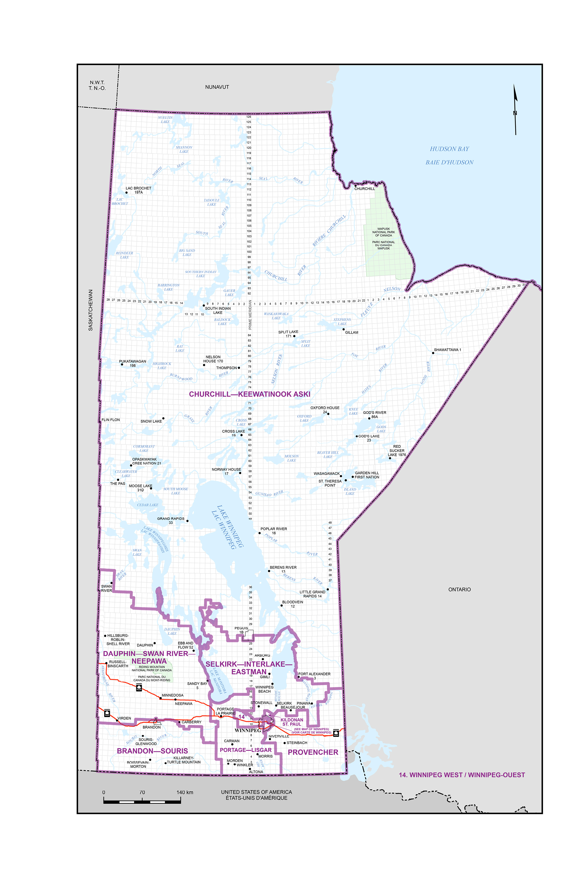
Brandon—Souris
(Population: 90,805)
(Map 1)
Consists of:
- (a) that part of the Province of Manitoba described as follows: commencing at the intersection of the western boundary of the Province of Manitoba with the northerly limit of the Rural Municipality of Pipestone; thence easterly along said limit and the northerly limit of the Rural Municipality of Sifton to the westerly boundary of Sioux Valley Dakota Nation Indian Reserve; thence southerly and generally easterly along said boundary and the northerly limit of the Rural Municpality of Sifton to the westerly limit of the Rural Municipality of Whitehead; thence northerly along the westerly limit of said rural municipality to the northerly limit of the Rural Municipality of Whitehead; thence generally easterly along the northerly limit of said rural municipality, the Rural Municipality of Cornwallis and the City of Brandon to the intersection of the easterly limit of the City of Brandon, the westerly limit of the Rural Municipality of Cornwallis with the Trans-Canada Highway (Highway 1); thence easterly, northeasterly and easterly along said highway to Highway 351; thence generally easterly along said highway to 85 Road West; thence southerly along said road to the production of Road 56 North; thence generally easterly along said road to Highway 5; thence southerly along said highway to the northerly limit of the Municipality of Glenboro-South Cypress; thence easterly, southerly and easterly along the northerly limit of said municipality to the westerly limit of the Rural Municipality of Victoria; thence northerly, easterly and generally southerly along the westerly, northerly and easterly limit of said rural municipality to the northerly limit of the Municipality of Lorne; thence generally easterly and southerly along the northerly and easterly limit of said municipality to the northerly limit of the Municipality of Pembina; thence southerly, easterly and southerly along the easterly limit of said municipality to the southern boundary of the Province of Manitoba; thence westerly and northerly along the southern and western boundaries of said province to the point of commencement; and
- (b) that part of the City of Brandon located in the Rural Municipality of Elton known as the Brandon Municipal Airport.
Churchill—Keewatinook Aski
(Population: 89,132)
(Map 1)
Consists of that part of the Province of Manitoba lying northerly and easterly of a line described as follows: commencing at the intersection of the western boundary of the Province of Manitoba and the northerly limit of the Municipality of Swan Valley West; thence easterly along said northerly limit to the westerly limit of the Municipality of Minitonas-Bowsman; thence southerly and easterly along the limit of said municipality to the westerly limit of the Rural Municipality of Mountain (South); thence generally southerly and easterly along the limit of said rural municipality to the westerly limit of the Rural Municipality of Mossey River; thence generally easterly, northerly and southerly along the limit of said rural municipality to the northerly limit of the Rural Municipality of Lakeshore; thence easterly and southerly along the limit of said rural municipality and the Rural Municipality of Alonsa (on the shoreline of Lake Manitoba) to Provincial Trunk Highway 68; thence southeasterly along said highway to the westerly limit of the Municipality of West Interlake; thence generally easterly and northerly along the limit of said municipality and the limit of the Rural Municipality of Grahamdale to the westerly limit of Fairford Indian Reserve No. 50 on the shoreline of Lake Winnipegosis; thence generally northerly, easterly and westerly along the said limit and the limit of the Rural Municipality of Grahamdale to the easterly limit of the Obushkudayang Indian Reserve; thence northerly and westerly along the limit of said Indian reserve to Provincial Road 513; thence westerly along said road to Martin Avenue; thence southerly along said avenue to 1 Street; thence westerly along said street to Provincial Road 513; thence soutwesterly along said road to Ivaniski Road; thence southerly along said road to St. Martin Road; thence easterly along said road to the easterly limit of the Rural Municipality of Grahamdale; thence generally southerly along said limit to the westerly limit of Fairford Indian Reserve No. 50 on the shoreline of Lake Winnipegosis; thence southerly along said limit to the limit of the Rural Municipality of Grahamdale; thence generally southeasterly and easterly along the limit of said rural municipality to the westerly limit of the Rural Municipality of Fisher; thence generally northerly and easterly along the limit of said rural municipality and the northerly limit of the Municipality of Bifrost-Riverton to the westerly shoreline of Washow Bay in Lake Winnipeg; thence generally southwesterly and northeasterly along said shoreline to the northeasterly most point of Anderson Point; thence northeasterly in a straight line across Lake Winnipeg on the easterly shoreline of said lake at latitude 51°26’36”N; thence generally southerly along said shoreline to the northerly limit of the Fort Alexander Indian Reserve No. 3; thence southwesterly in a straight line across Traverse Bay to the intersection of the shoreline with the easterly limit of the Rural Municipality of Alexander; thence generally southerly and easterly along the limit of said rural municipality to the westerly limit of the Town of Powerview-Pine Falls; thence generally northerly and easterly along the limit of said town to the westerly limit of the Rural Municipality of Alexander; thence generally easterly and southerly along the limit of said rural municipality to the northerly limit of Tp 16; thence east along said limit to the eastern boundary of the Province of Manitoba.
Excluding:
- (a) Manitou Island and Gunnlaugsson Island in the Lake Manitoba Narrows, belonging to the Rural Municipality of West Interlake; and
- (b) that part of the Municipality of Minitonas-Bowsman lying westerly of River Avenue (Provincial Road 366).
Dauphin—Swan River—Neepawa
(Population: 90,662)
(Map 1)
Consists of:
- (a) that part of the Province of Manitoba described as follows: commencing at the intersection of the western boundary of the Province of Manitoba with the northerly limit of the Municipality of Swan Valley West; thence easterly along the northerly limit of said municipality to the westerly limit of the Municipality of Minitonas-Bowsman; thence southerly and easterly along the limit of said municipality to the westerly limit of the Rural Municipality of Mountain (South); thence generally southerly and easterly along the limit of said rural municipality to the westerly limit of the Rural Municipality of Mossey River; thence generally easterly, northerly and southerly along the limit of said rural municipality to the northerly limit of the Rural Municipality of Lakeshore; thence easterly, southerly, easterly and generally southerly along the limit of said rural municipality, the easterly limit of the Rural Municipality of Alonsa (on the shoreline of Lake Manitoba) and the easterly limit of the Municipality of WestLake-Gladstone to the northerly limit of the Municipality of North Norfolk; thence southerly along said limit of said municipality to 60 Road North; thence generally easterly along said road to 43 Road West; thence southerly along said road to an approximate latitude 49°52′20″N and longitude 98°26′16″W (production of 59 Road North); thence easterly in a straight line to the Assiniboine River to an approximate latitude 49°52′19″N and longitude 98°25′09″W; thence generally northeasterly along said river to the westerly production of 60 Road North from 40 Road West; thence easterly in a straight line along said production to 40 Road West; thence southerly along said road and 240 Road to the northerly limit of the Rural Municipality of Grey; thence westerly along said limit to the easterly limit of the Municipality of Norfolk-Treherne; thence southerly, generally westerly and generally northerly along the easterly, southerly and westerly limit of said municipality to the southerly limit of the Municipality of North Norfolk; thence westerly along said limit to the easterly limit of the Municipality of North Cypress-Langford; thence southerly, westerly, northerly and westerly along the easterly and southerly limit of said municipality to Highway 5; thence northerly along said highway to 56 Road North; thence westerly along said road and its production to 85 Road West; thence northerly along said road to Highway 351; thence generally westerly along said highway to the Trans-Canada Highway (Highway 1); thence westerly and southwesterly along said highway to the southerly limit of the Rural Municipality of Elton; thence generally westerly along said limit and the southerly limit of the Municipality of Riverdale to the easterly boundary of Sioux Valley Dakota Nation Indian Reserve; thence southerly along said boundary and the easterly limit of the Rural Municipality of Wallace-Woodworth to the southerly limit of said rural municipality; thence generally westerly along said limit and the southerly boundary of Sioux Valley Dakota Nation Indian Reserve to the western boundary of the Province of Manitoba; thence north along said boundary to the point of commencement; excluding that part of the City of Brandon located in the Rural Municipality of Elton known as the Brandon Municipal Airport; and
- (b) that part of the Municipality of Minitonas-Bowsman lying westerly of River Avenue (Provincial Road 366).
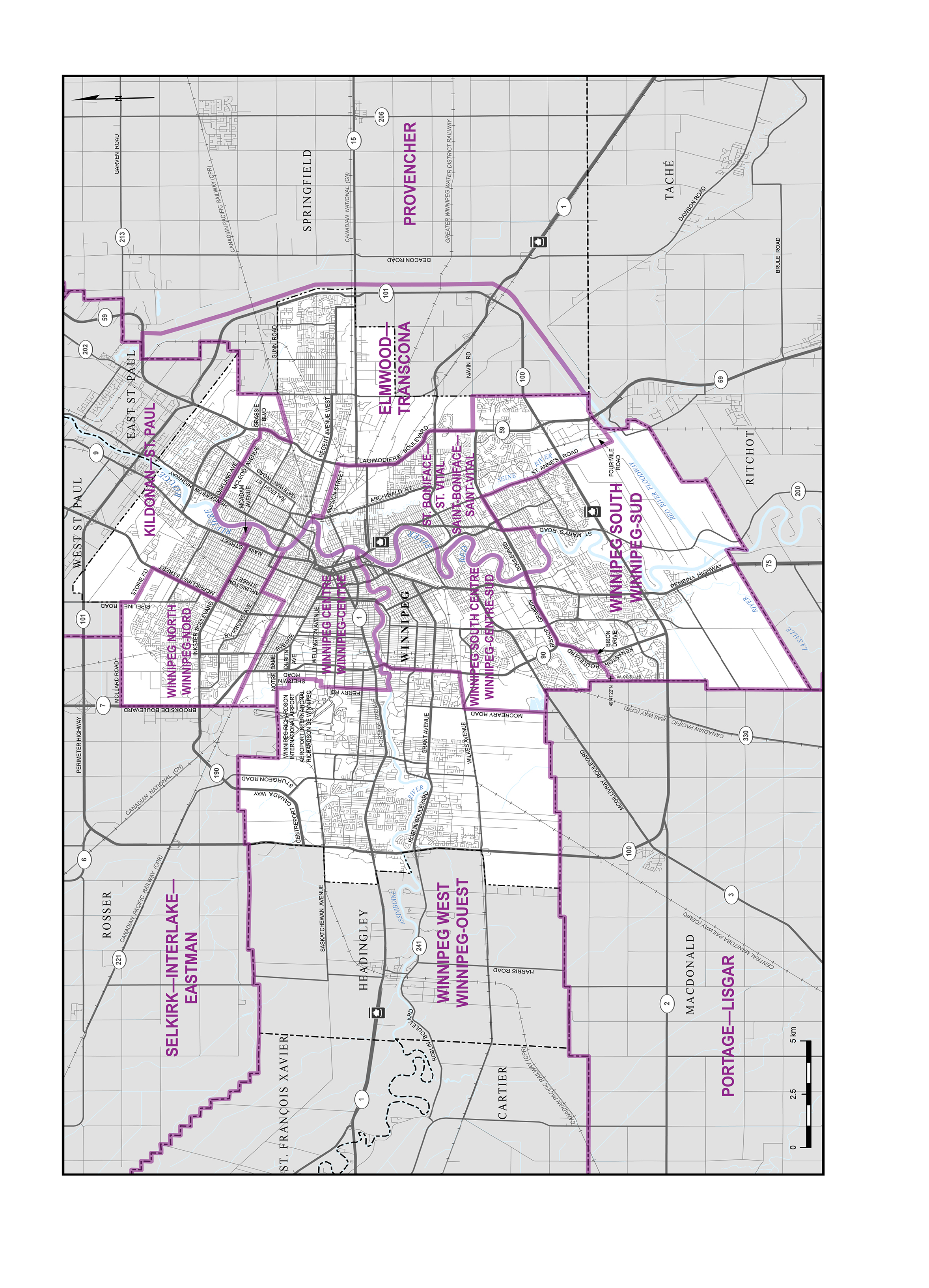
Elmwood—Transcona
(Population: 98,324)
(Map 2)
Consists of:
- (a) that part of the City of Winnipeg described as follows: commencing at the intersection of the Red River with the northwesterly production of Oakland Avenue; thence southeasterly along said production and Oakland Avenue to Raleigh Street; thence southwesterly along said street to McLeod Avenue; thence southeasterly along said avenue and Grassie Boulevard to Lagimodiere Boulevard; thence southerly and southwesterly along said boulevard to the Canadian Pacific Railway; thence easterly along said railway to the easterly limit of the City of Winnipeg (Plessis Road); thence easterly, generally southerly, westerly, southerly, westerly and southerly along said city limit to Navin Road; thence westerly along the westerly production of said road to Lagimodiere Boulevard; thence northerly, northwesterly and northerly along said boulevard to the easterly production of Mission Street; thence westerly along said production and Mission Street to the Canadian Pacific Railway; thence northerly, northwesterly and westerly along said railway to the Red River; thence generally northerly along said river to the point of commencement; and
- (b) that part of the Rural Municipality of Springfield lying southerly, westerly and northwesterly of a line described as follows: commencing at the intersection of the westerly limit of the Rural Municipality of Springfield and Lagimodiere Boulevard; thence easterly along said boulevard to the Red River Floodway; thence generally southerly and southwesterly along said floodway to the westerly limit of the Rural Municipality of Springfield.
Kildonan—St. Paul
(Population: 93,321)
(Map 2)
Consists of:
- (a) the rural municipalities of East St. Paul and West St. Paul; and
- (b) that part of the City of Winnipeg lying northeasterly and northerly of a line described as follows: commencing at the intersection of the easterly limit of said city with the Canadian Pacific Railway; thence westerly along said railway to Lagimodiere Boulevard; thence generally northeasterly along said boulevard to Grassie Boulevard; thence westerly and northwesterly along said boulevard and McLeod Avenue to Raleigh Street; thence northeasterly along said street to Oakland Avenue; thence northwesterly along said avenue and its northwest production to the Red River; thence generally southerly along said river to the southeasterly production of McAdam Avenue; thence northwesterly along said production, McAdam Avenue and its
- intermittent productions to Main Street; thence southwesterly along said street to Inkster Boulevard; thence northwesterly along said boulevard to McPhillips Street; thence northeasterly along said street to Storie Road; thence northwesterly along said road to Pipeline Road; thence northerly along said road to the westerly limit of the City of Winnipeg (near Mollard Road).
Portage—Lisgar
(Population: 100,441)
(Map 1)
Consists of that part of the Province of Manitoba described as follows: commencing at the intersection of the southern boundary of said province with the westerly limit of the Rural Municipality of Stanley; thence generally northerly along said limit to the southerly limit of the Rural Municipality of Thompson; thence westerly and northerly along the southerly and westerly limit of said rural municipality to the southerly limit of the Rural Municipality of Dufferin; thence generally northerly along the westerly limit of said rural municipality and the westerly limit of the Rural Municipality of Grey to the southerly limit of the Rural Municipality of Portage la Prairie; thence easterly along said limit to 240 Road; thence northerly along said road and 40 Road West to 60 Road North; thence westerly along the production of said road to the Assiniboine River; thence generally southwesterly along said river to approximate latitude 49°52′19″N and longitude 98°25′09″W; thence westerly in a straight line to 43 Road West at approximate latitude 49°52′20″N and longitude 98°26′16″W (also being the production of 59 Road North); thence northerly along said road to 60 Road North; thence generally westerly along said road to the westerly limit of the Rural Municipality of Portage la Prairie (being also the easterly limit of the Municipality of North Norfolk); thence generally northerly and generally easterly along the westerly and northerly limit (Lake Manitoba) of said rural municipality and the northwesterly limit (Lake Manitoba) of the Rural Municipality of Woodlands to the northerly limit of said rural municipality; thence easterly, generally northerly, easterly, southerly and generally westerly along the northerly, easterly and southerly limit of the Rural Municipality of Woodlands to the easterly limit of the Rural Municipality of Portage la Prairie; thence southerly along the easterly limit of said rural municipality to the easterly production of 430 Road; thence westerly along said production to 22 Road West; thence southerly along said road to the Trans-Canada Highway (Highway 1); thence southeasterly along said highway to the easterly limit of the Rural Municipality of Portage la Prairie; thence generally southerly along said limit to the northerly limit of the Rural Municipality of Grey; thence easterly along said limit to the westerly limit of the Rural Municipality of Macdonald; thence generally easterly and generally southerly along the northerly and easterly limit of said rural municipality to the northerly limit of the Rural Municipality of Morris; thence easterly along said limit to the westerly limit of the Rural Municipality of De Salaberry; thence easterly, southerly, easterly and generally southerly along the northerly and easterly limits of said rural municipality to the northerly limit of the Municipality of Emerson-Franklin; thence southerly along the easterly limit of said municipality to the southern boundary of the Province of Manitoba; thence west along said boundary to the point of commencement.
Provencher
(Population: 97,650)
(Map 1)
Consists of that part of the Province of Manitoba described as follows: commencing at the intersection of the southern boundary of said province with the westerly limit of the Rural Municipality of Stuartburn; thence generally northerly along said limit to the southerly limit of the Rural Municipality of Hanover; thence northerly, westerly, northerly and westerly along the limit of said rural municipality to the easterly limit of the Rural Municipality of Ritchot; thence westerly, generally northerly and generally northeasterly along the southerly, westerly and northerly limits of said rural municipality to the westerly limit of the Rural Municipality of Springfield; thence northerly along said limit to the Red River Floodway at approximate latitude 49°47′56″N and longitude 97°01′35″W; thence northeasterly and generally northerly along said floodway to Lagimodiere Boulevard (Highway 59); thence westerly along said boulevard to the westerly limit of the Rural Municipality of Springfield; thence northerly, easterly, northerly, generally northeasterly, easterly, southerly and easterly along the westerly and northerly limits of said rural municipality to the westerly limit of the Rural Municipality of Reynolds; thence northerly, easterly, southerly, easterly and northerly along the westerly and northerly limit of said rural municipality, the easterly limit of the Rural Municipality of Whitemouth and the easterly limit of the Local Government District of Pinawa to the southerly limit of the Rural Municipality of Lac du Bonnet (on Eleanor Lake); thence northerly along the easterly limit of said rural municipality to the southerly limit of the Rural Municipality of Alexander; thence easterly and generally northerly along the southerly and easterly limits of said rural municipality to the northerly limit of Tp 16; thence east along said limit to the eastern boundary of the Province of Manitoba; thence south and west along the eastern and southern boundaries of said province to the point of commencement.
St. Boniface—St. Vital
(Population: 98,751)
(Map 2)
Consists of that part of the City of Winnipeg described as follows: commencing at the intersection of the Red River with the Canadian Pacific Railway (near Elmwood Road); thence easterly, southeasterly and southerly along said railway to Mission Street; thence easterly along said street and its easterly production to Lagimodiere Boulevard; thence southerly, southeasterly and southerly along said boulevard to the westerly production of Navin Road at approximate latitude 49°50′29″N and longitude 97°02′58″W; thence easterly along said production to the easterly limit of the City of Winnipeg; thence southerly, westerly and southwesterly along said limit to the Seine River; thence southwesterly in a straight line to a point on Four Mile Road at approximate latitude 49°47′22″N and longitude 97°03′20″W; thence southwesterly along said road to St. Anne’s Road; thence northwesterly along said road to Bishop Grandin Boulevard; thence southwesterly along said boulevard to St. Mary’s Road; thence southerly along said road to River Road; thence southwesterly along said road to a point at approximate latitude 49°49′05″N and longitude 97°07′10″W; thence southeasterly in a straight line to a point at approximate latitude 49°49′03″N and longitude 97°07′09″W; thence southerly in a straight line to the Red River at approximate latitude 49°48′59″N and longitude 97°07′08″W; thence generally northerly along said river to the point of commencement.
Selkirk—Interlake—Eastman
(Population: 97,682)
(Map 1)
Consists of:
- (a) the rural municipalities of: Alexander, Armstrong, Bifrost-Riverton, Brokenhead, Coldwell, Fisher, Gimli, Lac du Bonnet, Rockwood, Rosser, St. Andrews, St. Clements, St. Laurent, Victoria Beach, West Interlake and Whitemouth;
- (b) the Rural Municipality of Grahamdale, excluding that part described as follows: commencing at the intersection of the westerly limit of the Obushkudayang Indian Reserve with Provincial Road 513; thence westerly along said road to Martin Avenue; thence southerly along said avenue to 1 Street; thence westerly along said street to Provincial Road 513; thence southwesterly along said road to Ivaniski Road; thence southerly along said road to St. Martin Road; thence easterly along said road to the easterly limit of the Rural Municipality of Grahamdale; thence generally northerly and easterly along the limit of said rural municipality to the southerly limit of the Obushkudayang Indian Reserve; thence generally westerly along the limit of said reserve to the point of commencement;
- (c) the Local Government District of Pinawa;
- (d) the City of Selkirk; the towns of Arborg, Beausejour, Lac du Bonnet, Powerview–Pine Falls, Stonewall, Teulon and Winnipeg Beach; the Village of Dunnottar;
- (e) the Indian reserves of Brokenhead No. 4 and Dog Creek No. 46;
- (f) that part of the Province of Manitoba described as follows: commencing at the intersection of the easterly limit of the Rural Municipality of Bifrost-Riverton with the southerly shoreline of Washow Bay in Lake Winnipeg; thence generally northeasterly along said shoreline to the northeasternmost point of Anderson Point; thence northeasterly in a straight line across Lake Winnipeg to the easterly shoreline of said lake at latitude 51°26′36″N; thence generally southerly along said shoreline to the northerly limit of Fort Alexander Indian Reserve No. 3; thence southwesterly in a straight line across Traverse Bay to the intersection of the shoreline with the easterly limit of the Rural Municipality of Alexander; thence generally westerly and northerly along the shoreline of Lake Winnipeg to the southerly limit of the Rural Municipality of Bifrost-Riverton at approximate latitude 51°07′36″N; thence westerly and northerly along the limit of said rural municipality to the point of commencement; and
- (g) Manitou Island and Gunnlaugsson Island in the Lake Manitoba Narrows, belonging to the Rural Municipality of West Interlake.
Winnipeg Centre
(Population: 96,951)
(Map 2)
Consists of that part of the City of Winnipeg described as follows: commencing at the intersection of the Red River with the Assiniboine River; thence generally westerly along the Assiniboine River to the southerly production of Ferry Road; thence northerly along said production and Ferry Road and its intermittent production to latitude 49°53′59″N; thence easterly in a straight line to a point at latitude 49°53′59″N and longitude 97°12′47″W; thence northerly in a straight line to Wellington Avenue at longitude 97°12′48″W; thence generally easterly along said avenue to the southerly production of Sherwin Road; thence northerly along said production and Sherwin Road to Dublin Avenue; thence westerly along the westerly production of said avenue to the southerly production of Airport Road; thence northerly along said production and Airport Road to Notre Dame Avenue; thence westerly along said avenue to the westerly limit of the City of Winnipeg (Brookside Boulevard); thence northerly along said limit to the main line of the Canadian Pacific Railway; thence southeasterly along said railway to Arlington Street; thence northeasterly along said street to Burrows Avenue; thence southeasterly along said avenue and its production to the Red River; thence generally southerly along said river to the point of commencement.
Winnipeg North
(Population: 95,082)
(Map 2)
Consists of that part of the City of Winnipeg described as follows: commencing at the intersection of the northerly limit of said city with Pipeline Road; thence southerly along said road to Storie Road; thence southeasterly along said road to McPhillips Street; thence southwesterly along said street to Inkster Boulevard; thence southeasterly along said boulevard to Main Street; thence northerly along said street to McAdam Avenue; thence southeasterly along said avenue and its intermittent productions to the Red River; thence generally southwesterly along said river to the southeasterly production of Burrows Avenue; thence northwesterly along said production and Burrows Avenue to Arlington Street; thence southwesterly along said street to the main line of the Canadian Pacific Railway; thence northwesterly along said railway to the westerly limit of the City of Winnipeg (Brookside Boulevard); thence northerly and easterly along the westerly and northerly limits of said city to the point of commencement.
Winnipeg South
(Population: 95,515)
(Map 2)
Consists of that part of the City of Winnipeg lying westerly and southerly of a line described as follows: commencing at the intersection of the Seine River with the easterly limit of said city; thence southwesterly in a straight line to a point on Four Mile Road at approximate latitude 49°47′22″N and longitude 97°03′20″W; thence southwesterly along said road to St. Anne’s Road; thence northwesterly along said road to Bishop Grandin Boulevard; thence southwesterly along said boulevard to St. Mary’s Road; thence southerly along said road to River Road; thence southwesterly along said road to a point at approximate latitude 49°49′05″N and longitude 97°07′10″W; thence southeasterly in a straight line to a point at approximate latitude 49°49′03″N and longitude 97°07′09″W; thence southerly in a straight line to the Red River at approximate latitude 49°48′59″N and longitude 97°07′08″W; thence westerly and northerly along said river to Bishop Grandin Boulevard; thence generally southwesterly along said boulevard to the northbound lane of Kenaston Boulevard; thence generally southerly along said boulevard to Bison Drive; thence southwesterly along said drive to Appleford Gate; thence southerly along said road to a point at approximate latitude 49°47′22″N and longitude 97°12′38″W; thence westerly in a straight line to a point at approximate latitude 49°47′22″N and longitude 97°12′43″W; thence southerly in a straight line to a point at approximate latitude 49°47′19″N and longitude 97°12′44″W; thence westerly in a straight line to the westerly limit of the City of Winnipeg (Brady Road) at approximate latitude 49°47′19″N and longitude 97°12′50″W.
Winnipeg South Centre
(Population: 100,160)
(Map 2)
Consists of that part of the City of Winnipeg described as follows: commencing at the intersection of the Assiniboine River and Kenaston Boulevard (at St James Bridge); thence southerly along said boulevard to the easterly production of Wilkes Avenue; thence westerly along said production and Wilkes Avenue to McCreary Road; thence southerly along said road to the southerly limit of the City of Winnipeg (Wyper Road); thence generally easterly, southerly, easterly and southerly along the southerly and westerly limits of said city to a point at approximate latitude 49°47′19″N and longitude 97°12′50″W; thence easterly in a straight line to a point at approximate latitude 49°47′19″N and longitude 97°12′44″W; thence northerly in a straight line to a point at approximate latitude 49°47′22″N and longitude 97°12′43″W; thence easterly in a straight line to Appleford Gate at approximate latitude 49°47′22″N and longitude 97°12′38″W; thence northerly along said road to Bison Drive; thence generally northeasterly along said drive to the northbound lane of Kenaston Boulevard; thence generally northerly along said boulevard to Bishop Grandin Boulevard; thence generally northeasterly along said boulevard to the Red River; thence generally northerly along said river to the Assiniboine River; thence generally westerly along said river to the point of commencement.
Winnipeg West
(Population: 97,677)
(Map 1 and 2)
Consists of:
- (a) the rural municipalities of Cartier, Headingley and St. François Xavier;
- (b) that part of the Rural Municipality of Portage la Prairie lying northerly, easterly and southerly of a line described as follows: commencing at the intersection of the easterly limit of said rural municipality and the Trans-Canada Highway (Highway 1); thence westerly along said highway to 22 Road West; thence northerly along said road to 430 Road; thence easterly along the easterly production of said road to the easterly limit of the Rural Municipality of Portage la Prairie; and
- (c) that part of the City of Winnipeg lying westerly of a line described as follows: commencing at the intersection of the westerly limit of said city (Brookside Boulevard) and Notre Dame Avenue; thence easterly along said avenue to Airport Road; thence generally southerly along said road and its production to the westerly production of Dublin Avenue; thence easterly along said avenue to Sherwin Road; thence southerly along said road and its production to Wellington Avenue; thence generally westerly along said avenue to a point at approximate latitude 49°54′06″N and longitude 97°12′48″W; thence southerly in a straight line to a point at approximate latitude 49°53′59″N and longitude 97°12′47″W; thence westerly in a straight line to the northerly production of Ferry Road at latitude 49°53′59″N; thence southerly along said road and its intermittent productions to the Assiniboine River; thence generally easterly along said river to Kenaston Boulevard (at St James Bridge); thence southerly along said boulevard to a point at approximate latitude 49°50′49″N and longitude 97°12′28″W; thence westerly in a straight line to a point at approximate latitude 49°50′49″N and longitude 97°12′42″W; thence westerly in a straight line to McCreary Road; thence southerly along said road to the southerly limit of the City of Winnipeg (Wyper Road).
Map 1 – Manitoba
Map 2 – City of Winnipeg